Study - mapping of underwater relief & ecosystems in the Aegean Sea (PE3)
Over the last decades, efforts have been made to identify and assess the geomorphological and environmental changes that the Mediterranean Sea has undergone. The application of acoustic (geophysical) remote sensing methods has contributed to mapping part of the marine topography, seabed geomorphology and the geological structure of the background, but the coverage is still low. Extensive areas, particularly those less than 300-400 m deep, remain unexplored and a number of scientific questions remain open and unresolved. The study of the paleo-climatic and geomorphological changes in the South Aegean and its associated marine physiographic units is a scientific priority, since it is believed that they determined to a significant extent the paleo-environmental conditions of the Eastern Mediterranean. The response of the sea surface to paleo-climatic changes caused the emergence or submergence of the continental shelf and thus provided the available space for land-based migration bridges for prehistoric humans and other organisms.
Another important scientific issue, whose understanding is a prerequisite for sustainable management of marine ecosystems, is knowledge of the type, quality, quantity and spatial distribution of modern marine habitats.
The above research issues fall within the thematic priorities of the Region of South Aegean for Environment and Sustainable Development and the collection of the necessary primary data will be carried out during the research missions of the “Alkyon”
RSP. In
addition, under WP 3, the operation of the laboratory and other infrastructures of the Rhodes Hydrobiological Station and the operational capabilities of the Hydrobiological Station “Alkyon”
will be ensured through regular inspections/maintenance and upgrading/completion of the laboratory, scientific, technical, naval and E/M equipment.
Furthermore, in FP3 it is foreseen to fully train members of the new scientific staff of the Hellenic Space Agency / Hellenic Research
Centre in the use and maintenance of the existing scientific equipment of the Alkyon
HFCS / HFCS (Multibeam Bathymetry System or MBES, Bottom Bottom Bottom Structure Acoustic Tomography System or SBP, Automatic Conductivity – Temperature – Depth Recording System or CTD, ADCP devices, etc.).), as well as that to be purchased under the Act (Remotely Operated Underwater Vehicle or ROV, Strike Sampler, etc.) for the upgrade of the ROV. The ROV is used in a wide range of research (sample collection, filming, etc.) and training activities, as well as rescue activities of the Hellenic Centre for Marine Research (wreck certification, recovery operations). Regarding
the training of scientific staff in the use and maintenance of Remotely Operated Underwater Vehicles, this will be done through in-house training with the contribution of the ROVs team of ELCETH or by attending courses in a specialised centre abroad (ROV Pilot/Technician Grade II level and in accordance with the IMCAC 005 guidelines).
In particular, in addition to the research activities and the recruitment and training of new scientific staff, FP3 includes: – the
completion of the scientific equipment of the Alkyon/VRC by the supply of a shock sampler,
– the completion of the navigation equipment of the Alkyon/VRC and the Circe/VRC by the supply and installation of instruments such as an Automatic Identification System (AIS), – the
completion of the equipment of the YSSR and the “Alkyon”/ELCETF with the supply of PCs, peripherals and accessories,
– the regular control/maintenance of the electronic equipment of the “Alkyon”/ELCETF and the “Circe”/ELCETF (inboard engines, winches, A-frame of the “Alkyon” ROV and outboard engine of the “Circe” F/V) for the first and second year of the Act,
– the regular control/maintenance of the SBE19 Seacat Profiler
Automatic Recorder, as well as the SBE33 Deck Unit of the Automatic Recorder System (CTD) of the “Alkyon”/ELCDF ROV, – the
regular inspection/maintenance, for two (2) years (1+1), of the IMU Subsystem of the Multi-Dimensional Bathymetry
System of the Alkyon/ELCETHEP,
– the supplementation of the marine equipment of the Alkyon/ELCETHEP with the supply of various items of marine equipment (ropes, floats, etc.)the supply of various types of marine equipment (ropes, ropes, rope, etc.) and spare parts for the E/M equipment of the Alcyon Marine Research Centre / ELKETHE to replace those that will be damaged or destroyed during the research project, and
– the supplementation of the technical maintenance equipment of the Alcyon Marine
Research Centre / ELKETHE with the supply of tools, electronic – electro-technical – electrical devices and materials.
2) Contribution to the identification of past changes in sea surface and submarine geoarchaeological potential
Climate changes in the geological past have resulted in the fluctuation of the sea surface, which in cold (glacial) periods was 110-130 m lower than its present position and in warm (interglacial) periods was 5-10 m higher than today. During the glacial phases most of the shelves were land, while during the interglacial phases they were covered by the sea. These changes have left their geomorphological and environmental footprints on the continental shelves, and their detailed study provides a wealth of reliable information on the succession of physical conditions that shaped the present-day submarine landscape. The results of these surveys are widely used to improve predictions, on a local or regional scale, of the rate of sea surface variation in the near future and the impact of this process on the natural and anthropogenic system. The available equipment of the “Alkyon” RSP (see below) allows the detailed bathymetric and geomorphological mapping of the coastal and submarine area of the South Aegean Region as well as the identification of the relevant sedimentological and erosional footprints left by long-term sea surface movements. The discovery of evidence for the position of the coastline on islands of the South Aegean during the recent geological past (at least, the last 20,000 years) will highlight the response of the area to paleo-climatic changes. The emergence of all or most of the islands’ continental shelf during the last glacial period created land communication bridges, which prehistoric man used to migrate to areas of abundant natural resources. The subsequent rise in sea level inundated the bridges and disrupted the seamless migratory link. In the context of the investigation of the impacts of paleo-climate change and the related sea surface fluctuations, case studies of the submarine space in island clusters of the South Aegean (e.g. Kos-Kalymnos-Pserimo, Naxos-Paros-Mykonos-Mykonos-Dilos-Rhinia) will be carried out. The paleogeographic connectivity of the areas of interest will be reconstructed in successive time steps, and their geoarchaeological potential will be assessed, highlighting the underwater cultural heritage of the area.
3) Contribute to the mapping of submarine relief, habitats and geological substrate Habitat
maps have become an essential tool for environmental monitoring, spatial planning and marine resource assessment. Scientific knowledge of the extent and geographical range of benthic habitats in the South Aegean Region is extremely poor due to the limited capabilities of conventional seabed survey methods, which were exclusively applied until a few years ago. It is estimated that less than 5-10% of the marine area has been mapped at a resolution similar to that applied in terrestrial habitat studies. In
recent years, marine research in the South Aegean Sea using the scientific equipment at the Alkyon Marine
Research Station has contributed to the acquisition of datasets related to the biogeographic characteristics of the seabed and, consequently, to the production of continuous, detailed, large-scale maps of the different types of marine habitats.
The mapping of the substrate
types of the island of Rhodes carried out in the framework of the INTERREG GR-CY 2007-2013 project “AKTI: Shaping & Pilot Implementation of SEZ Plans in Rhodes and Cyprus” provided a large number of derived seabed parameters (e.g. loose sediment grain size, bottom slope, acoustic variability, hardness, roughness, etc.) and contributed to the mapping of specific habitat types. The existing information will be used as reference data and will be compared with the corresponding data collected in the framework of the present project, from the same area using the same methodology, in order to determine the possible changes that have occurred in the ecosystem in the last 7-8 years due to natural and/or anthropogenic processes. It should be noted that the baseline information from this Work Package will be combined with IPs 5 – 7 to eventually produce the marine habitat distribution maps.
Deliverables
P3.1: Determination of past changes in sea surface and submarine geo-archaeological potential of areas of interest in the SE Aegean (Technical Report)

P3.2: Mapping of modern geological substrate types in the submarine area around the island of Rhodes (Technical Report)

P3.3: Shock sampler for the “Alcyon” / Hellenic Research Institute of Geosciences and Natural History
P3.4: Automatic Identification System (AIS) for the Alcyon GNSS / Hellenic Research and Development Centre
P3.5: PCs, peripherals and accessories for the HFSR/EELCATH and the Alkyon GNSS/ELCATH


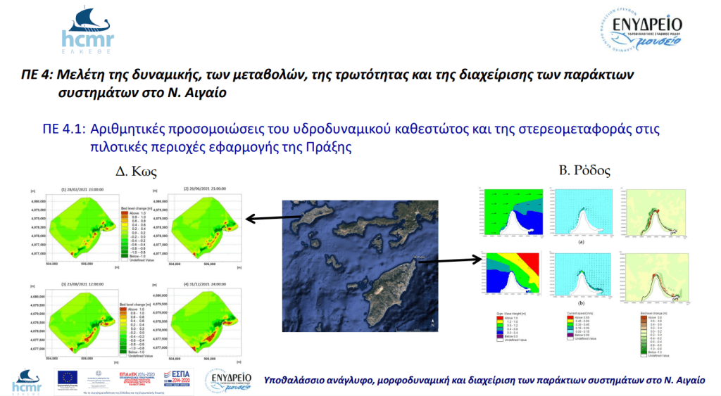
Study of dynamics, changes, vulnerability and management of coastal systems in S. Aegean (PE4)
The coastal zone of the islands of the South Aegean Region is a complex and sensitive system that undergoes continuous geomorphological and environmental changes due to the long term influence of natural and anthropogenic processes. Therefore, the study of the morphodynamic evolution of the beaches and the understanding, assessment and operational forecasting/response of the coastal function in selected islands with high tourism development (e.g. Rhodes, Kos, Santorini, etc.) is a priority for their integrated management.
The scientific approach will involve the following successive stages:
A) Collection of existing data and information
– Meteorological parameters (wind intensity and direction, air temperature, precipitation, sunshine, evaporation, relative humidity, wave height and direction, etc.)
– Topography of the terrestrial and submarine terrain (in paper or digital form)
– Hydrology at catchment level and hydrogeology of the wider area.
– Geology and tectonics of the wider area.
– Land cover and land use of the terrestrial, coastal and marine areas and identification of protected areas. –
Soil and sedimentology of river basins and coasts.
– Socio-economic parameters (demographic data, administrative structure, employment, GDP, entrepreneurship, primary/secondary/tertiary production, historical and cultural).
B) Determination of long-term (more than 10 years) shoreline changes on the beaches under study using historical aerial photographs and satellite images, digitisation of the shorelines using the ArcGIS Geographical Information System, and quantification of the time-spatial changes of the shoreline using the Digital Shoreline Analysis System (DSAS) module. Based on the results of the above analysis, the areas of longitudinal retreat, stability or advance and the rate of change of these will be identified.
C) Collection, evaluation and mapping of geomorphological, sedimentological, ecological and hydrodynamic characteristics of the shorelines A
topographic and bathymetric survey of the terrestrial and submarine part of the shorelines under study will be carried out, as well as collection and analysis of coastal sediments using the existing and new scientific equipment of the YSP and the “Alkyon”/HELKETHE. Single digital topography/soil models of the terrestrial and submarine part of the coast will be created and subsequently the results of the sedimentological (grain size) analyses and the local hydrodynamic regime will be adapted to the appropriate digital format and layout for input into a numerical model.
D) Application of numerical models for the simulation and/or prediction of the coastal system morphodynamics
The short and long waves in the coastal areas of the islands of the South Aegean Region under study will be analysed and simulated on the basis of the Boussinesq
type equations. The simulation will concern the combined effect of shoaling, refraction, diffraction, partial reflection and transmission, bottom dissipation, wave breaking, run-up, frequency spreading, directional spreading and non-linear wave-wave interaction. In addition, the interaction of coastal morphology and wave interaction will be investigated under common and extreme conditions that have occurred in the recent past or are expected to occur in the next 50 and 100 years. Subsequently, the transport of non-cohesive material under wave and current action will be simulated and the amount and rate of sandy sediment stereotransport in the study areas will be investigated. However, the simulation of the stereotransport of fine-grained (muddy) material in the submarine part of the beaches, as well as the long-term prediction of the shoreline changes of the beaches under study will be done with the help of specialised modules of the existing MIKE 21 model, but also with the help of open source software.
E) Assessment of the vulnerability of the coastline to potential sea level rise in the coming decades due to climate change
The vulnerability of the coastline will be assessed, which depends mainly on geomorphology, shoreline movement rate, coastal slope, significant incoming wave height, tidal range and the rate of relative sea level rise. Coastal exposure to long-term sea level rise will be
taken into account and the degree of risk will be mapped. Three climate change scenarios (baseline, optimistic and pessimistic) will be explored, as envisaged by the UN Intergovernmental Panel on Climate Change (IPCC).
F) Development of management actions to prevent, intervene and address the impacts of natural hazards and disasters on the coastline under study and preparation of feasible proposals
– Risk assessment (predictability, useful warning time, speed of occurrence of the disaster, duration and severity of the disaster, probability of recurrence of the disaster, controllability, scope for avoiding the disaster or its consequences)
– Operational design (decision maker, method, timing and
warning
groups and targets) – Planning of the operationalisation (decision maker, method, timing and target groups
G) Formulation of a dynamic and multidimensional strategy for Integrated Coastal Zone Management (ICZM)
The ever-changing nature of socio-economic and environmental conditions, their complex interactions and the nature of management itself will be periodically defined in order to propose updated, targeted, effective and commonly accepted solutions.
P4.1: Numerical simulations of the hydrodynamic regime and of the solid transport in the pilot areas of the project (Technical Report)
P4.2: Coastal vulnerability assessment and the necessary management actions to prevent, intervene and address the impacts of natural hazards and disasters in the pilot areas of the project (Technical Report)

Assessment of the ecological quality of coastal benthic biocommunities, recording of alien species and anthropogenic pressures in the marine ecosystem of the S. Aegean (PE5)
Α) Ecological quality of benthic biocoenoses
The principle of “ecological quality” of water (EQA) was developed by the European Union to be used as a framework for European water policy and its innovation lies in the incorporation of biological indicators as criteria for quality assessment. The implementation of the Water Framework Directive (2000/60/EU) in Greece started in 2012 with the implementation of ELKEΘE and the operation of the national surface water quality monitoring network of the country (implementation of Article 8 of the WFD). A total of 121 stations are monitored, of which 85 stations in coastal waters and 36 stations in transitional waters; of these in coastal waters 52 are supervisory monitoring stations and 33 are operational monitoring stations, where the achievement of good quality is considered to be at risk. The three key biological elements for the classification of ecological status under the WFD are phytoplankton, phytobenthos (macrophytes and angiosperms) and zooplankton. Zoebenthos include organisms living attached to or in direct contact with the seabed and, due to their direct and permanent contact with the substrate, they accurately reflect any environmental changes, especially when the cause of the disturbance is distinguished by a relative stability in space and time. The benthic biotic communities of the South Aegean Region have been studied in the past opportunistically, with the exception of the coastal and marine area of the island of Rhodes (Pancucci-Papadopoulou et al., 1999; Louizidou et al, 2011; Simbura, 2017). In the coastal area of the Rhodes Hydrobiological Station’s Aquarium, there is one monitoring station, whose ecological status, based on the biological element of zoobenthos, is estimated to be high.
The aim of the WP 5 is to investigate the ecological status of the coastal areas and other islands of the Aegean Region by sampling benthic biota and analysing the data from the islands of Rhodes, Kos, Naxos, Koufonisia and Santorini and then assessing their ecological status based on the biological index BENTIX (Simboura & Zenetos, 2002), which is applied in the framework of the IPM. The results of the IP will be combined with those of the other research IPs to map coastal habitats and identify environmental pressures and trends. In
addition, under FP5, the basic equipment of the laboratory of hydrology – benthic ecology – biopathology will be completed, which will operate in the space created by the implementation of FP1.
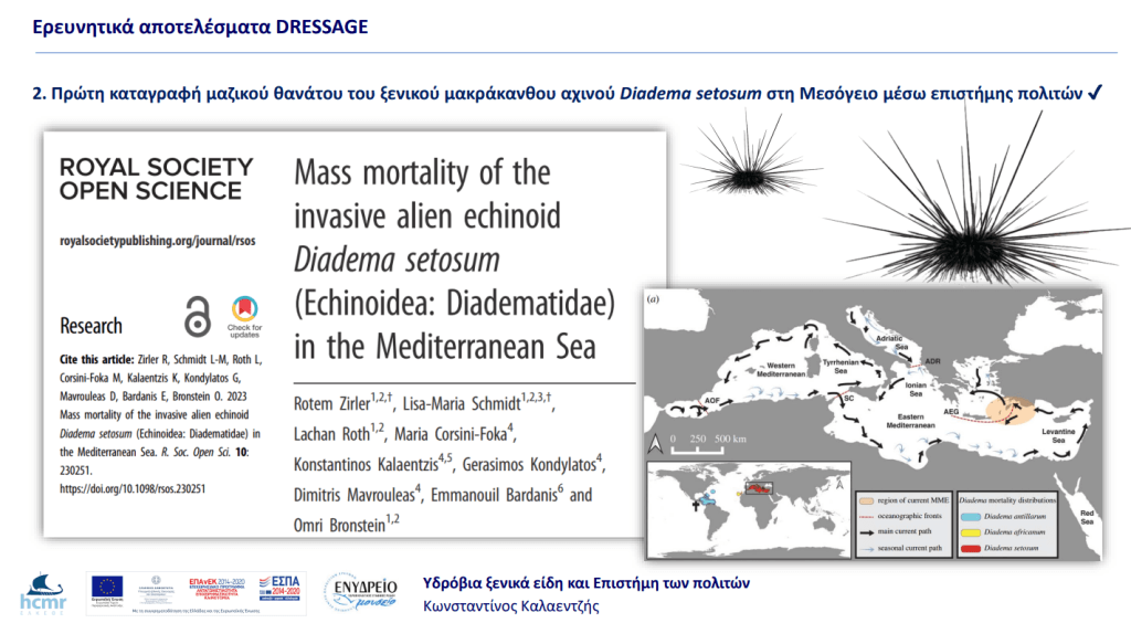
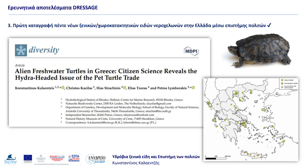
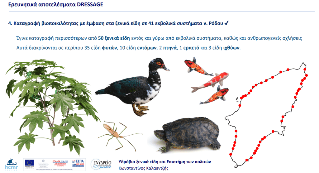
b) Inventory of alien species
It is well known that biological invasions have led to an unprecedented environmental crisis as a result of climate change and anthropogenic activities. such as the continuous increase in international trade (Hulme, 2009? Katsanevakis et al., 2014; Chown et al., 2015; Seebens et al., 2017). In the Mediterranean in particular, more than 1000 alien species (including cryptogenic ones; Zenetos et al., 2022) have been reported in the Mediterranean as a result of the opening of the Suez Canal, intensification of international trade, aquaculture and trade in aquarium species (Zenetos et al., 2012; Katsanevakis et al., 2013).
However, limited resources available for purely academic approaches may reduce data on the presence of new alien species, resulting in large gaps in research on alien species (Crall et al., 2010). Public participation in alien species research can potentially prove to be a very important source of data on the distribution, abundance, behaviour and impacts of alien species (Chandler et al., 2017; Johnson et al., 2020), and several initiatives are already taking shape in Greece (e.g. Giovos et al., 2019; Kalaentzis et al., 2021).
Therefore, the inventory of invasive species in the wider marine area of the South Aegean through citizen science data is an equally important objective of FP5, which will contribute to the assessment of pressures on coastal benthic ecosystems. The collection of citizen science data will be carried out through the construction of a platform on the Rhodes Hydrobiological Station website. On the platform, in addition to the possibility of submitting data, citizen scientists will be able to learn about the alien species that have been recorded so far in the Aegean region, those expected to arrive in the near future, as well as a guide with instructions on how to take photographs for the correct identification of alien species.
C) Anthropogenic impacts In
recent years, plastic pollution has emerged as the greatest threat to biodiversity and wildlife, surpassing even the threat of invasive alien species that have entered Greek waters mainly through the Suez Canal (Wright & Kelly, 2017). Especially marine mammals and sea turtles face the greatest risk from large and small plastics in the marine environment, as they consume them by mistaking them for food.
The South Aegean region and specifically east of the island of Rhodes, in the Lindos marine area, is the second deepest point in the Mediterranean Sea (4,433 m depth) (Stergiou et all., 1997) and is one of the main habitats of Cetaceans in Greece as these animals live and breed at great depths. Similarly, the coastline of Rhodes is one of the few remaining habitats for the breeding of sea turtles (Caretta caretta, Chelonia mydas), the former of which is classified as a protected species by the IUCN (IUCN, 2022). Recent strandings of Cetaceans as well as sea turtles have shown that the death of animals was mainly caused by ingestion of plastics. Earlier reports from strandings reported the main cause of death as being blows from boat propellers, ingestion of hooks or other causes. Increased use of plastics, insufficient collection and low recycling rates increase the number of plastics entering the marine ecosystem.
The laboratory facilities to be established at the YSP (see WP 1) and their equipment (Deliverable 5.2) could support future studies on washed-up animals, such as analyses of stomach contents from Cetaceans and sea turtles. In addition, the YSP will organise information dissemination, information and public awareness actions (Deliverable 5.3 and WP 9) on environmental protection, reduction of plastic use, recycling, coastal clean-up actions and workshops on Cetaceans of Greece, sea turtles and the marine environment as a whole.
D) Diving routes
The underwater caves and caves of the tidal zone are habitats of special interest as they host a high biodiversity (Gerovasileiou & Voultsiadou 2012) and have been classified as Priority Habitats by the EU (EU Habitats Directive, Code 8330). In the Aegean marine area, more than 600 sea caves have been recorded with most of them located in the South Aegean (Sini et al. 2017). Especially the Dodecanese region contains marine protected areas (MPAs) (Kasos-Karpathos-Saria and Ormos Apolakkia) where rare and protected species (turtles, seals, etc.) live.
An effort will therefore be made to identify, record and map the underwater caves and the species living in them, as well as to design diving routes in order to familiarise the public with emblematic Mediterranean ecosystems and marine biodiversity.
Deliverables
P5.1: Ecological quality assessment of the study islands of the Aegean Region (Technical Report)
P5.2: Basic equipment for the laboratory of the laboratory of hydrology – benthic ecology – biopathology of the YSP / ELKEΘE
P5.3: Online platform for citizen science data collection

Effects of anthropogenic and climatic pressures on the sea meadows of the S. Aegean (PE6)
Τα θαλάσσια λιβάδια
Η παράκτια ζώνη του Ν. Αιγαίου παρέχει πλήθος αγαθών και υπηρεσιών που αφορούν στο θαλάσσιο οικοσύστημα. Παράλληλα, η παράκτια ζώνη εξυπηρετεί ποικίλες ανθρώπινες δραστηριότητες (π.χ. τουρισμός, αλιεία, υδατοκαλλιέργειες, υπηρεσίες αναψυχής, μεταφορές, ναυσιπλοΐα κλπ.), πολλές από τις οποίες είναι επιζήμιες για τα ευαίσθητα παράκτια οικοσυστήματα. Πληθώρα Ευρωπαϊκών οδηγιών (π.χ. Habitat, Water Frame, Marine Strategy and Biodiversity Directives) επιβάλλουν την ολοκληρωμένη διαχείριση της παράκτιας ζώνης, η οποία με τη σειρά της προϋποθέτει την εκτίμηση της οικολογικής κατάστασης των ευαίσθητων οικοσυστημάτων που χρήζουν προστασίας (π.χ. λιβάδια Posidonia oceanica) και των καίριων υπηρεσιών που αυτά προσφέρουν σε σχέση με τις διάφορες οχλήσεις της παράκτιας ζώνης.
Το ΠΕ 6 αντιπροσωπεύει μια διεπιστημονική προσέγγιση στη μελέτη της επίδρασης των ανθρωπογενών και κλιματικών πιέσεων στα θαλάσσια λιβάδια του Ν. Αιγαίου. Κύριος σκοπός του είναι να εκτιμηθεί η υγεία και βασικές οικοσυστημικές υπηρεσίες των θαλάσσιων λιβαδιών στην εν λόγω περιοχή, να κατανοηθεί η απόκρισή τους στις πολλαπλές πιέσεις και να τεθούν βάσεις για τις αναγκαίες μελλοντικές δράσεις παρακολούθησης.
State-of-the-art
Τα θαλάσσια λιβάδια κατατάσσονται μεταξύ των πιο πολύτιμων παράκτιων οικοσυστημάτων στον πλανήτη βάσει των αγαθών και των υπηρεσιών που παρέχουν, συμπεριλαμβανομένων της υψηλής βιοποικιλότητας και παραγωγικότητας τους, της προστασίας των ακτών από τη διάβρωση και της αποθήκευσης άνθρακα. Ωστόσο, τα θαλάσσια λιβάδια μειώνονται με ανησυχητικούς ρυθμούς παγκοσμίως (1,5% ετησίως, Waycott et al. 2009) εξαιτίας κυρίως της υπέρμετρης παράκτιας οικιστικής ανάπτυξης, της υποβάθμισης της ποιότητας του νερού και της κλιματικής αλλαγής. Τα θαλάσσια λιβάδια είναι ιδιαίτερα ευάλωτα στη θέρμανση, καθώς η θερμική καταπόνηση παρεμποδίζει βασικές φυσιολογικές διεργασίες, όπως η φωτοσύνθεση, η αναπνοή και ο κύκλος του άνθρακα (Marba et al. 2015). Η Μεσόγειος Θάλασσα θερμαίνεται δύο-τρεις φορές ταχύτερα από τον παγκόσμιο ωκεανό (Diffenbaugh et al. 2007) και μια ταχεία αύξηση της μέσης θερμοκρασίας της επιφάνειας της θάλασσας (Sea Surface Temperature, SST) και της συχνότητας και της διάρκειας των κυμάτων καύσωνα προβλέπεται για το μέλλον (Giorgi & Lionello 2008). Αυτό συμβαίνει επειδή η Μεσόγειος είναι (1) ανάμεσα σε δύο κλιματικά συστήματα, την ξηρή Βόρεια Αφρική και το εύκρατο κλίμα της κεντρικής Ευρώπης, το οποίο καθιστά το μεσογειακό κλίμα ευάλωτο ακόμη και σε μικρές μεταβολές στην υδάτινη κυκλοφορία, και (2) μια ημι-κλειστή λεκάνη με περιορισμένη υδρολογική ανταλλαγή με τον Ατλαντικό Ωκεανό, με αποτέλεσμα χρόνο παραμονής των υδάτων περίπου τα 100 έτη και δυνατότητα αποθήκευσης θερμότητας. Η θερινή SST έχει ήδη αυξηθεί κατά 1.15 oC κατά τη διάρκεια των τελευταίων τριών δεκαετιών, επηρεάζοντας δυσμενώς τους μεσογειακούς οργανισμούς (Marba et al. 2015). Οι διαθέσιμες πληροφορίες δείχνουν τη μαζική θνησιμότητα του κυρίαρχου και ενδημικού θαλάσσιου φανερόγαμου Posidonia oceanica (L.) Delile (Marbà & Duarte 2010). Το Posidonia oceanica (L.) Delile σχηματίζει εκτενή λιβάδια, τα οποία προστατεύονται από την Οδηγία για τα Ενδιαιτήματα (92/43/ΕEC) ως ενδιαιτήματα προτεραιότητας (1120 *), αλλά δυστυχώς τα οικολογικά μοντέλα προβλέπουν τη λειτουργική εξαφάνισή του μέχρι το 2049 (Jorda et al. 2012). Ωστόσο, όλες οι πληροφορίες προέρχονται από τη Δυτική Μεσόγειο, ενώ δεν υπάρχουν δεδομένα σχετικά με τα θαλάσσια μακρόφυτα από την Ανατολική Μεσόγειο, όπου η θέρμανση είναι ιδιαίτερα έντονη. Πράγματι, η SST διαφοροποιείται γεωγραφικά κατά μήκος της Μεσογείου, με υψηλότερες καλοκαιρινές τιμές και τρεις φορές ταχύτερη τάση θέρμανσης στην Α. Μεσόγειο κατά την περίοδο 1985 – 2011. Μια πρόσφατη ανασκόπηση έδειξε ότι το 50% των βιολογικών επιπτώσεων εμφανίστηκαν σε θερινή SST 27 °C και ανωμαλία στη θερμοκρασία ≤ 4.5 °C, αν και τα δεδομένα αυτά αφορούν στη ΒΔ. Μεσόγειο, πιθανώς υποτιμώντας τις επιπτώσεις της θέρμανσης στο ανατολικό τμήμα (Marba et al. 2015).
Επιπλέον, τα θαλάσσια λιβάδια επηρεάζονται από πολλαπλές ανθρωπογενείς πιέσεις (Halpern et al. 2008) και ένα σημαντικό μέρος της λεκάνης της Μεσογείου (20%) επηρεάζεται ήδη σε μεγάλο βαθμό από αθροιστικές επιπτώσεις (Micheli et al. 2013). Η θέρμανση λειτουργεί συνεργικά με άλλους επιβαρυντικούς παράγοντες, όπως η οικιστική και τουριστική ανάπτυξη, η διάθεση λυμάτων και η γεωργική απορροή, που οδηγούν σε υποξία και συνεπαγόμενο στρες των μακροφύτων από υδρόθειο (Apostolaki et al. 2018). Οι πολλαπλές πιέσεις επηρεάζουν περισσότερο από το 50% των εθνικών χωρικών υδάτων της Ελλάδας (ύψος επίπτωσης μεσαίο 8,47 έως υψηλό 12) (Micheli et al. 2013), γεγονός που υποδηλώνει ότι τα θαλάσσια λιβάδια της θερμότερης Α. Μεσογείου μπορεί να είναι περισσότερο ευάλωτα στη θέρμανση, αν και εξ όσων γνωρίζουμε δεν υπάρχουν τέτοια δεδομένα μέχρι στιγμής. Η θέρμανση της Μεσογείου διευκολύνει τον αποικισμό και την εξάπλωση των ξενικών μακροφυτών με τροπική / υποτροπική προέλευση (Raitsos et al. 2010), όπως το Halophila stipulacea (Forsskål) Ascherson 1867, ένα θαλάσσιο φανερόγαμο γηγενές στον Ινδικό Ωκεανό και την Ερυθρά Θάλασσα, που σήμερα επεκτείνεται στην Ανατολική Μεσόγειο έως την Τυνησία (Telesca et al. 2015). Η βιολογική εισβολή μεταβάλλει την αυτόχθονη βιοποικιλότητα και έχει ως αποτέλεσμα την ‘τροπικοποίηση’ της Μεσογείου, υπονομεύοντας τη δομή και λειτουργία των γηγενών οικοσυστημάτων (Simberloff et al. 2013). Η Μεσόγειος δέχεται τον μεγαλύτερο αριθμό εισβολικών ειδών παγκοσμίως (Galil 2008) λόγω της διάνοιξης της διώρυγας του Σουέζ, της θαλάσσιας κυκλοφορίας και των υδατοκαλλιεργειών, ενώ μέχρι το 2016 είχαν ήδη εδραιωθεί 821 είδη (Zenetos et al. 2017). Μεταξύ των ευρωπαϊκών θαλασσών, η Α. Μεσόγειος φιλοξενεί τον μεγαλύτερο αριθμό εισβολέων (Galil et al. 2014) με την περιοχή των Δωδεκανήσων να βάλλεται ιδιαίτερα. Η διεύρυνση της διώρυγας του Σουέζ, που εκτιμάται ότι θα διπλασιάσει την τρέχουσα θαλάσσια κυκλοφορία μέχρι το 2023, αναμένεται να προκαλέσει επιπλέον αύξηση στο ρυθμό εισβολής ειδών από την Ερυθρά Θάλασσα στο εγγύς μέλλον. Η υποβάθμιση των θαλάσσιων λιβαδιών αυξάνει την ευπάθειά τους στην εισβολή. Παρόλο που επί του παρόντος δεν υπάρχουν ενδείξεις χωροτακτισμού του H. stipulacea στη Μεσόγειο (Boudouresque at al. 2009), η επέκτασή του στην Καραϊβική (Ruiz & Ballantine 2004) είχε επιβλαβή επίδραση στο αυτόχθονο ομόλογό του Thalassia testudinum, όταν το πρώτο έφτασε σε υψηλές πυκνότητες ως αποτέλεσμα του θρεπτικού εμπλουτισμού της περιοχής. Οι οικοσυστημικές υπηρεσίες ποικίλλουν μεταξύ των γενών των θαλάσσιων φανερόγαμων, με το γένος Posidonia να κατατάσσεται μεταξύ των σημαντικότερων σε αντίθεση με το γένος Halophila (Mtwana Nordlund et al. 2016). Συνεπώς, η πιθανή εξάπλωση του H. stipulacea με παράλληλη υποχώρηση του P. oceanica ως αποτέλεσμα της θέρμανσης προσδώσει ανταγωνιστικό πλεονέκτημα στο H. stipulacea σε σχέση με το γηγενές είδος ή ακόμη και οδηγήσει σε αντικατάσταση του τελευταίου, γεγονός που θα μπορούσε να καταλήξει σε σημαντική μείωση των οικοσυστημικών υπηρεσιών που παρέχονται στη συγκεκριμένη περιοχή. Ως εκ τούτου, η κατανόηση του ρόλου των ξενικών ειδών στην τροποποίηση της δομής και λειτουργίας των οικοσυστημάτων αποτελεί μείζονα πρόκληση για την οικολογία των θαλάσσιων οικοσυστημάτων (Borja 2014), αν και οι υπάρχουσες πληροφορίες σχετικά με το Η. stipulacea είναι πολύ περιορισμένες σε σύγκριση με τα γηγενή ομόλογά του.
Τα θαλάσσια λιβάδια είναι υπεύθυνα για περισσότερο από το 10% του οργανικού άνθρακα που αποθηκεύεται στον ωκεανό ετησίως (Fourqurean et al. 2012), γεγονός που καθιστά τα θαλάσσια λιβάδια μεταξύ των πιο σημαντικών αποθηκών Μπλε Άνθρακα (Blue Carbon, BC) (Duarte 2017). Η έννοια του μπλε άνθρακα (Blue Carbon) εισήχθη κατά αναλογία με τον πράσινο άνθρακα για να αναδείξει ότι τα παράκτια φυτικά οικοσυστήματα, όπως είναι τα θαλάσσια λιβάδια, μαζί με τα αλοέλη και τα μαγγρόβια δάση, συμβάλλουν σημαντικά στη δέσμευση του άνθρακα, όπως κάνουν και τα χερσαία δάση. Όντας φυτικά οικοσυστήματα, τα θαλάσσια λιβάδια προσλαμβάνουν διοξείδιο του άνθρακα (CO2) μέσω της φωτοσύνθεσης και παράγουν οργανική ύλη, η οποία οργανική ύλη κατακρατείται μόνιμα από το υποκείμενο ίζημα. Με αυτόν τον τρόπο, τα θαλάσσια λιβάδια μπορούν να απορροφήσουν ένα σημαντικό μέρος της περίσσειας του CO2 που εκλύεται στην ατμόσφαιρα από την καύση ορυκτών καυσίμων, συμβάλλοντας στην αντιμετώπισης της κλιματικής αλλαγής. Στην πραγματικότητα, τα θαλάσσια λιβάδια συγκαταλέγονται μεταξύ των πιο σημαντικών αποθηκών μπλε άνθρακα, συμβάλλοντας στον μετριασμό της κλιματικής αλλαγής. Παρότι τα λιβάδια P. oceanica είναι ένας εξαιρετικός βιότοπος όσον αφορά στην αποθήκευση άνθρακα, το μέγεθος των αποθηκών ποικίλλει ανάλογα με τις γεωμορφολογικές και υδρολογικές συνθήκες και την ανθρωπογενή πίεση. Ωστόσο, οι εκτιμήσεις σχετικά με την ιζηματαπόθεση και αποθήκευση άνθρακα στα θαλάσσια λιβάδια είναι ακόμη περιορισμένες και όλες οι διαθέσιμες εκτιμήσεις ως τώρα προέρχονται μόνο από τη Δυτική Μεσόγειο (Mazarrasa et al. 2017), ενώ δεν υπάρχουν σχετικές εκτιμήσεις για το BC στα λιβάδια P. oceanica της Α. Μεσογείου.
Το γεγονός ότι έχει αποδειχθεί η απώλεια της ικανότητας αποθήκευσης άνθρακα ως αποτέλεσμα της ανθρωπογενούς πίεσης (Serrano et al. 2016) και της θέρμανσης σε αυστραλιανά θαλάσσια φανερόγαμα υποδηλώνει ότι τα λιβάδια P. oceanica που επηρεάζονται από πολλαπλές πιέσεις ενδέχεται επίσης να χάσουν την ικανότητά τους να δεσμεύουν άνθρακα. Εκτιμάται ότι ο σημερινός ρυθμός απώλειας των θαλάσσιων λιβαδιών (1,5%) θα μπορούσε να οδηγήσει στην απελευθέρωση μέχρι 299 Tg άνθρακα ετησίως (Fourqurean et al. 2012) μετατοπίζοντας τελικά τα λιβάδια από αποθήκες σε πηγές άνθρακα. Αυτό που μας λείπει είναι μια μηχανιστική κατανόηση του πώς η κατάρρευση των λιβαδιών θα μπορούσε να έχει διαδοχικές επιπτώσεις στη δυναμική του άνθρακα προκειμένου να ποσοτικοποιηθεί ο κίνδυνος μετατόπισης των θαλάσσιων λιβαδιών από αποθήκες άνθρακα σε πηγές άνθρακα. Πρόσφατες μελέτες στα θαλάσσια λιβάδια έχουν υποδείξει ότι περιβαλλοντικές ή ανθρωπογενείς πιέσεις μπορούν να προκαλέσουν μετατόπιση της κατάστασης των λιβαδιών (regime shift). Τέτοιες μετατοπίσεις μπορούν να συμβούν κατά τη διέλευση των περιβαλλοντικών ορίων με μη αναστρέψιμες αλλαγές στην λειτουργία και τις οικοσυστημικές υπηρεσίες. Αυτές οι μεταβάσεις ονομάζονται κρίσιμα σημεία (tipping points) και συνδέεται με την απώλεια ανθεκτικότητας της τρέχουσας κατάστασης και την ριζική αλλαγή σε μια νέα κατάσταση (Dakos et al 2019). Αν και έχουν περιγραφεί τέτοια σημεία για τα θαλάσσια λιβάδια, δεν υπάρχει πληροφορία με την πιθανή αρνητική σχέση μεταξύ της κατάστασης των λιβαδιών και της δυναμικής του άνθρακα που αυτά κατακρατούν.
Επιστημονική, οικονομική και κοινωνική απήχηση
Το ΠΕ 6 θα συμβάλει στην κατανόηση της ανθεκτικότητας των παράκτιων μεσογειακών οικοσυστημάτων σε περιβαλλοντικές διαταραχές. Η πρόταση αναμένεται να παράγει πρωτογενή πληροφoρία για τα σημαντικά ευαίσθητα παράκτια ενδιαιτήματα του Ν. Αιγαίου, μια οικο-περιοχή της Μεσογείου που πλήττεται περισσότερο από την υπερθέρμανση και την εισβολή εξωτικών ειδών, όσον αφορά:
– στη δυναμική πληθυσμών και τα δημογραφικά προφίλ των λιβαδιών P. Oceanica, και
– στο δυναμικό μπλε άνθρακα των θαλάσσιων λιβαδιών.
Τα αποτελέσματα θα συμπληρώσουν το σετ δεδομένων που είναι ήδη διαθέσιμο για τη Δ. Μεσόγειο, παρέχοντας έτσι μια ολοκληρωμένη εικόνα της τρέχουσας κατάστασης στη Μεσόγειο και της συνεχιζόμενης αντίδρασης των παράκτιων οικοσυστημάτων στις πολλαπλές πιέσεις. Η πρόταση επικεντρώνεται στο σημαντικό ενδημικό είδος P. oceanica, το οποίο κατέχει ρόλο «μηχανικών του οικοσυστήματος» υψηλής οικολογικής και οικονομικής σημασίας για τη Μεσόγειο. Ως εκ τούτου τα αναμενόμενα αποτελέσματα θα συμβάλουν σημαντικά στη προστασία και διαχείριση της Μεσογείου, εξασφαλίζοντας την παροχή των σχετικών οικοσυστημικών υπηρεσιών (π.χ. αλιεία, προστασία των ακτών από τη διάβρωση). Τα αναμενόμενα αποτελέσματα θα διαδοθούν ευρέως σε εξειδικευμένο και ευρύ κοινό, αυξάνοντας τις γνώσεις και το ενδιαφέρον για τη βιοποικιλότητα και τους ευαίσθητους θαλάσσιους οικοτόπους. Τέλος, το ΠΕ θα προσφέρει ευκαιρίες απασχόλησης σε έναν νεαρό επιστήμονα και θα εμπλουτίσει το βιογραφικό των μελών της Ομάδας Έργου. Βάσει των παραπάνω, το ΠΕ θα συμβάλλει στην εφαρμογή των ευρωπαϊκών στρατηγικών για την προστασία του θαλάσσιου περιβάλλοντος (Habitat Directive, Water Frame Directive, Marine Strategy, Biodiversity Strategy 2020) και την αειφόρο ανάπτυξη (Blue Growth, Europe 2020).
Επιστημονική μεθοδολογία/Σχέδιο υλοποίησης
Η μελέτη θα επικεντρωθεί σε θαλάσσια λιβάδια P. oceanica σε διάφορες περιοχές του Ν. Αιγαίου με διαφορετικές περιβαλλοντικές και βιογεωχημικές συνθήκες και ανθρωπογενείς πιέσεις.
Παραδοτέα
Π6.1: Εκτίμηση της ανθεκτικότητας των θαλάσσιων λιβαδιών P. οceanica του Ν. Αιγαίου (Τεχνική Έκθεση)
Π6.2.1 Εκτίμηση της ανθεκτικότητας και την ευπάθειας των λιβαδιών P. οceanica σε περιοχές με διαφορετικό βαθμό κλιματικής και ανθρωπογενούς πίεσης
Π6.2.2 Χαρτογράφηση της έκτασης και του όγκου των υφάλων P. οceanica με την χρήση σεισμό-ακουστικών μεθόδων υψηλής ανάλυσης (side scan sonar, multi-beam, sub-bottom profiler)
Π6.2.3 Εκτίμηση της ανθεκτικότητας των λιβαδιών βάσει του ιστορικού αύξησης των βλαστών στις περιοχές μελέτης. Τα θαλάσσια φανερόγαμα είναι ριζωματώδη φυτά που αναπτύσσονται με επανάληψη ενός περιορισμένου συνόλου μονάδων. Το ιστορικό αύξησής τους μπορεί να ανακατασκευαστεί από τα ξεχωριστά σημάδια που αφήνουν τα φύλλα και τα άνθη στο μακρόβιο ρίζωμα, επιτρέποντας έτσι την ανίχνευση και τον προσδιορισμό της προγενέστερης αύξησης
Π6.2: Εκτίμηση της ικανότητας αποθήκευσης άνθρακα των θαλάσσιων λιβαδιών P. οceanica του Ν. Αιγαίου (Τεχνική Έκθεση)
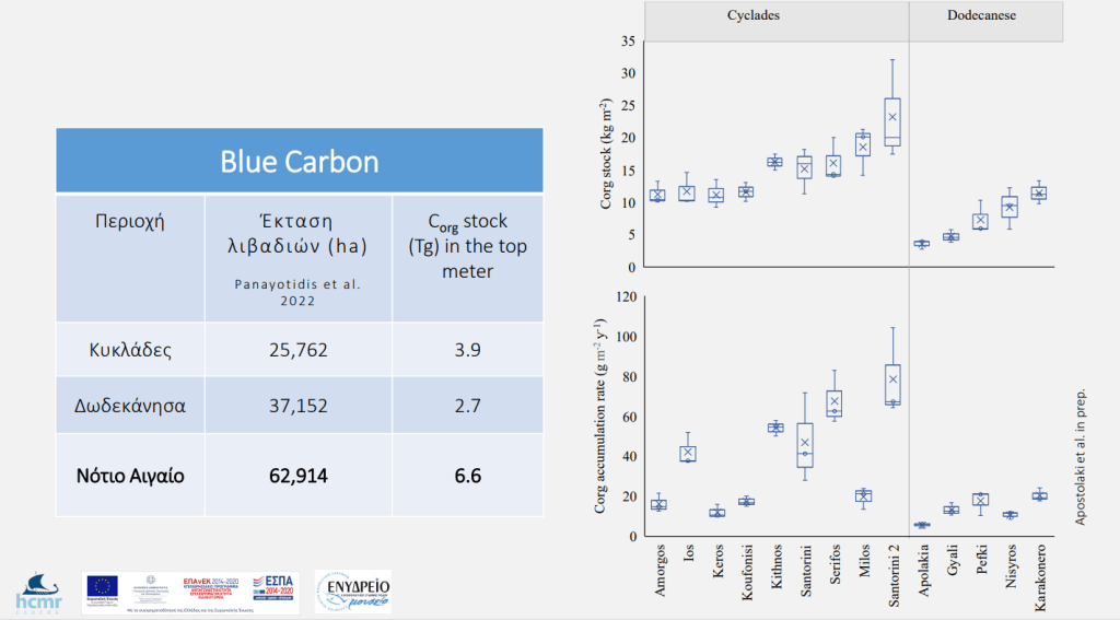
Π6.2.1 Εκτίμηση της ιζηματαπόθεσης και της αποθήκευσης του Blue Carbon των θαλάσσιων λιβαδιών P. oceanica με τη συλλογή πυρήνων ιζήματος (1 m βάθος ιζήματος) από περιοχές του Ν. Αιγαίου με διαφορετικές περιβαλλοντικές και βιογεωχημικές συνθήκες και βαθμό επίδρασης των ανθρωπογενών και κλιματικών πιέσεων. Τα ιζήματα θα αναλυθούν για οργανικό και ανόργανο άνθρακα ώστε να γίνει η εκτίμηση των αποθηκών και θα εξετασθεί η ισοτοπική σύνθεση (δ13C) των ιστών P. oceanica και των ιζημάτων για να προσδιοριστεί η συμβολή των θρυμμάτων των θαλάσσιων φανερόγαμων στην δεξαμενή οργανικού άνθρακα· επίσης, θα μετρηθεί η κατακόρυφη κατανομή των 210Pbx στους πυρήνες για να υπολογιστεί ο ρυθμός ιζηματαπόθεσης άνθρακα
Π6.2.2 Εκτίμηση της μετατόπισης των θαλάσσιων λιβαδιών από αποθήκες σε πηγές άνθρακα ως αποτέλεσμα των ανθρωπογενών πιέσεων. Θα διερευνηθεί τη δυνατότητα εφαρμογής της θεωρίας των κρίσιμων σημείων (tipping points) προκειμένου να αναπτυχθεί ένα μοντέλο που θα περιγράφει τη χωρική δυναμική της ανάπτυξης και της υποβάθμισης των λιβαδιών P. oceanica και τον τρόπο με τον οποίο μπορεί να συμβεί μετατόπιση στο καθεστώς (regime shift) ενός λιβαδιού (σσ. μετατροπή από αποθήκη σε πηγή άνθρακα)
Assessment of the environmental status of benthic types of habitats of community interest in the S. Aegean using ecosystem indicators (PE7)
Βενθικοί τύποι οικοτόπων κοινοτικού ενδιαφέροντος
Για τη διαχείριση των ανθρώπινων δραστηριοτήτων, η Οδηγία 2008/56/ΕΚ του Ευρωπαϊκού Κοινοβουλίου για τη Θαλάσσια Στρατηγική ακολουθεί την οικοσυστημική προσέγγιση, η οποία εξασφαλίζει ότι η συνολική πίεση των δραστηριοτήτων αυτών παραμένει σε επίπεδα που είναι συμβατά με την επίτευξη καλής περιβαλλοντικής κατάστασης και ότι δεν τίθεται σε κίνδυνο η ικανότητα των θαλάσσιων οικοσυστημάτων να αντιδρούν στις ανθρωπογενείς αλλαγές, ενώ ταυτόχρονα επιτρέπουν την αειφόρο χρήση των θαλάσσιων αγαθών και υπηρεσιών από τη σημερινή και τις μελλοντικές γενεές (Ν.3983/2011).
Το ΠΕ 7 αποσκοπεί́ στην εκτίμηση της τρέχουσας οικολογικής κατάστασης, καθώς και την ιεράρχηση των πιέσεων και απειλών επί των θαλάσσιων τύπων οικοτόπων των παράκτιων περιοχών της Περιφέρειας Ν. Αιγαίου, σε επιλεγμένες περιοχές των Κυκλάδων και Δωδεκανήσων με έμφαση σε περιοχές του Δικτύου Natura 2000.
Στο πλαίσιο της παρούσας προσέγγισης, θα μελετηθούν τα δομικά και λειτουργικά στοιχεία των υφάλων και των λιβαδιών του φανερόγαμου Posidonia oceanica, καθώς οι δυο αυτοί τύποι οικοτόπων κοινοτικού ενδιαφέροντος (1170 και 1120 αντίστοιχα, Οδηγία 92/43/EΚ) παρουσιάζουν τη μέγιστη βιομάζα στα παράκτια Μεσογειακά οικοσυστήματα (La Mesa et al. 2011; Giakoumi & Kokkoris, 2013) και υποστηρίζουν ένα σημαντικό εύρος οικοσυστημικών υπηρεσιών (Salomidi et al. 2012). Για την εκτίμηση της οικολογικής κατάστασης των υπό μελέτη οικοτόπων, θα εφαρμοστούν δείκτες που θα λαμβάνουν υπόψη πλήθος θεμελιωδών παραμέτρων δια μέσου των παράκτιων τροφικών πλεγμάτων, μεταξύ των οποίων η σύνθεση των βενθικών κοινωνιών και των ιχθυοπληθυσμών (Salomidi et al. 2016).
Τα αποτελέσματα θα συνδυαστούν με αυτά́ των λοιπών σχετικών ερευνητικών ΠΕ για την κατά το δυνατό πληρέστερη καταγραφή και αξιολόγηση των βενθικών οικοσυστημάτων.
Παραδοτέα
Π7.1: Εκτίμηση περιβαλλοντικής κατάστασης βενθικών τύπων οικοτόπων κοινοτικού ενδιαφέροντος στο Ν. Αιγαίο (Τεχνική́ Έκθεση): Αξιολόγηση της περιβαλλοντικής κατάστασης των παράκτιων υφάλων και λιβαδιών Ποσειδωνίας και εκτίμηση τρεχουσών πιέσεων και απειλών στην ευρύτερη περιφέρεια του Ν. Αιγαίου

Π7.2: Στόχοι Διατήρησης και Μέτρα Προστασίας βενθικών τύπων οικοτόπων κοινοτικού ενδιαφέροντος στο Ν. Αιγαίο (Τεχνική Έκθεση): Διαμόρφωση προτεινόμενων Στόχων Διατήρησης και Μέτρων Προστασίας Υφάλων και Λιβαδιών Ποσειδωνίας του Ν. Αιγαίου στα πλαίσια της οικοσυστημικής προσέγγισης
Assessment of underwater noise levels from navigation in the S. Aegean (PE8)
Ένας μεγάλος αριθμός θαλάσσιων ζώων αντιλαμβάνεται το υποθαλάσσιο περιβάλλον στο οποίο ζει μέσω του ήχου, λόγω του ότι στο περιβάλλον αυτό ο ήχος διαδίδεται πολύ καλύτερα από το φως, και συνεπώς παίζει βασικό ρόλο στην επικοινωνία, την πλοήγηση, τον προσανατολισμό, τη σίτιση και την ανίχνευση των θηρευτών. Η αυξανόμενη εισαγωγή θορύβου στο θαλάσσιο περιβάλλον μπορεί να έχει αρνητικές επιπτώσεις στα θαλάσσια ζώα: μειώνει τα εύρη επικοινωνίας και αποκρύπτει τους ήχους ενδιαφέροντος (masking), διαταράσσει την αναπαραγωγική συμπεριφορά, επηρεάζει τους προϋπολογισμούς ενέργειας μέσω παρεμβολών σε αναζήτηση τροφής και αυξημένων ταξιδιών, αποκλείει τα ζώα μακροπρόθεσμα από ορισμένους σημαντικούς οικοτόπους, προκαλεί χρόνιες αντιδράσεις στρες, προκαλεί προσωρινή ή μόνιμη απώλεια ευαισθησίας στην ακοή, προκαλεί σωματικό τραυματισμό, και σε ακραίες περιπτώσεις, προκαλεί θάνατο των ζώων.
Ο ανθρωπογενής θόρυβος στο θαλάσσιο περιβάλλον έχει αυξηθεί τα τελευταία 100 περίπου χρόνια λόγω της ανάπτυξης ποικίλων δραστηριοτήτων (Prospathopoulos, 2016). Ο ανθρωπογενής υποθαλάσσιος θόρυβος, που αναφέρεται επίσημα ως πηγή ρύπανσης, αναγνωρίζεται πλέον ως ένα πολύ περίπλοκο παγκόσμιο ζήτημα που πρέπει να αντιμετωπιστεί αποτελεσματικά. Η Οδηγία-Πλαίσιο για τη Θαλάσσια Στρατηγική (ΟΠΘΣ, 2008/56/EΚ), μια ευρωπαϊκή πρωτοβουλία σε επίπεδο πολιτικής με στόχο την επίτευξη Καλής Περιβαλλοντικής Κατάστασης (ΚΠΚ) του ευρωπαϊκού θαλάσσιου περιβάλλοντος, έχει συμπεριλάβει τον υποθαλάσσιο θόρυβο μέσω του Χαρακτηριστικού Περιγραφής 11 (D11: «Η εισαγωγή ενέργειας, συμπεριλαμβανομένου του υποβρύχιου θορύβου, είναι σε επίπεδα που δεν επηρεάζουν δυσμενώς το θαλάσσιο περιβάλλον»), ενός από τα έντεκα που Χαρακτηριστικά Περιγραφής που χαρακτηρίζουν την ΚΠΚ. Περαιτέρω, η ΟΠΘΣ διακρίνει το θόρυβο σε παλμικό (impulsive) και συνεχή (continuous) και, σύμφωνα με την Απόφαση (ΕΕ) 2017/848 της Επιτροπής (Commission) της 17ης Μαΐου 2017, θεσπίζει κριτήρια και μεθοδολογικά πρότυπα για την ΚΠΚ των θαλάσσιων υδάτων καθώς και προδιαγραφών και τυποποιημένων μεθόδων για την παρακολούθηση και την αξιολόγηση των κινδύνων για τον παλμικό και συνεχή θόρυβο.
Σύμφωνα με την ανωτέρω Απόφαση, το κύριο κριτήριο για την επίτευξη ΚΠΚ σε ό,τι αφορά στο συνεχή θόρυβο, απαιτεί εκτίμηση της χωρικής κατανομής, της χρονικής έκτασης και των επιπέδων συνεχών ήχων χαμηλής συχνότητας, ανθρωπογενούς προέλευσης, καθώς και καθορισμό οριακών τιμών η υπέρβαση των οποίων σημαίνει ότι υπάρχει σημαντική πιθανότητα για δυσμενείς επιδράσεις σε πληθυσμούς θαλάσσιων ζώων. Επίσης, στην ίδια Απόφαση δίδονται προδιαγραφές και τυποποιημένες μέθοδοι για την παρακολούθηση και την αξιολόγηση του εν λόγω κριτηρίου, οι οποίες εστιάζουν στην παρακολούθηση της ηχητικής πίεσης σε ζώνες συχνοτήτων γύρω από τα 63 και 125 Hz. Για αυτήν την περιοχή συχνοτήτων είναι γνωστό ότι η βασική συνιστώσα ανθρωπογενούς θορύβου είναι ο θόρυβος ναυσιπλοΐας, δηλαδή ο θόρυβος που προέρχεται από τα πλοία (βλ., π.χ., Hildebrand, 2009). Επίσης, είναι γνωστό ότι στις συχνότητες αυτές οι συνθήκες διάδοσης στο θαλάσσιο περιβάλλον ευνοούν την μετάδοση του θορύβου σε μεγάλες αποστάσεις, και συνεπώς η συνεισφορά των πλοίων στα επίπεδα θορύβου παραμένει σημαντική ακόμη και όταν αυτά βρίσκονται μακριά από το σημείο υπολογισμού.
Λαμβάνοντας υπόψη τα ανωτέρω, καθώς και τις διεθνείς ερευνητικές προσπάθειες σχετικά με τις πιθανές αρνητικές επιπτώσεις του θορύβου ναυσιπλοΐας σε ένα μεγάλο αριθμό θαλάσσιων ειδών (Erbe at al., 2019, Weilgart, 2018), η εκτίμηση των επιπέδων υποθαλάσσιου θορύβου από τη ναυσιπλοΐα σε περιοχές που αποτελούν το ενδιαίτημα πληθυσμών θαλάσσιων ζώων είναι σημαντική, σε συνδυασμό με τον καθορισμό των οριακών τιμών, για τα μέτρα που θα ληφθούν στο άμεσο μέλλον προκειμένου να επιτευχθεί ο στόχος της ΚΠΚ. Στα θαλάσσια ύδατα της Περιφέρειας Ν. Αιγαίου φιλοξενούνται τουλάχιστον επτά είδη θαλάσσιων θηλαστικών: έξι είδη κητωδών (Frantzis and Alexiadou, 2003), το σταχτοδέλφινο, το ρινοδέλφινο, το ζωνοδέλφινο (τρωτό σύμφωνα με την Διεθνή Ένωση Προστασίας της Φύσης, IUCN) και λιγότερο συχνά κοινό δελφίνι (κινδυνεύον), ο ζιφιός και ο φυσητήρας (κινδυνεύον), και η πλέον απειλούμενη (κρισίμως κινδυνεύον) Μεσογειακή φώκια (https://el.mom.gr/katanomi), καθώς και ένας μεγάλος αριθμός ψαριών και ασπόνδυλων. Συνεπώς, η εκτίμηση των επιπέδων υποθαλάσσιου θορύβου από τη ναυσιπλοΐα στο Ν. Αιγαίο είναι απαραίτητο στάδιο για την αποτίμηση της επικινδυνότητας που αυτός (ο θόρυβος) ενέχει όσον αφορά στις επιπτώσεις στα ανωτέρω θαλάσσια ζώα.
Σε αυτή την ενότητα εργασίας η εκτίμηση των επιπέδων υποθαλάσσιου θορύβου από τη ναυσιπλοΐα θα επιτευχθεί αποκλειστικά με τη χρήση μαθηματικής μοντελοποίησης αξιοποιώντας προηγούμενες σχετικές μελέτες (Ollivier et al., 2019, Athanassoulis et al., 2018, Skarsoulis et al., 2017). Η χρήση μαθηματικών μοντέλων για την εκτίμηση των εν λόγω επιπέδων αποτελεί εξαιρετικά χρήσιμο εργαλείο, δεδομένου ότι οι μετρήσεις σε μεμονωμένους σταθμούς παρακολούθησης επάγουν σημαντικά κόστη αγοράς εξοπλισμού και συντήρησης και δεν μπορούν να καλύψουν ευρείες περιοχές. Παρόλα αυτά, η σύγκριση των αποτελεσμάτων ενός αριθμητικού μοντέλου με σημειακές μετρήσεις θεωρείται απαραίτητη για τη ρύθμιση του μοντέλου και την επαλήθευση των αποτελεσμάτων. Για το λόγο αυτό, αλλά και για λόγους ευθυγράμμισης του ενότητας εργασίας με το Εθνικό Πρόγραμμα Παρακολούθησης για την ΟΠΘΣ (ΕΣΠΑ-ΥΜΕΠΕΡΑΑ, 2018), η προτεινόμενη μελέτη θα γίνει σε στενή συνεργασία με το Πρόγραμμα αυτό (βλ. επίσης, Prospathopoulos, 2017).
Τα βασικά βήματα για την εκτίμηση των επιπέδων υποθαλάσσιου θορύβου από τη ναυσιπλοΐα μέσω μοντελοποίησης είναι τα ακόλουθα:
– Συλλογή περιβαλλοντικών δεδομένων για την περιοχή μελέτης (βαθυμετρία, εποχικά δεδομένα για θερμοκρασία και αλατότητα στη στήλη του νερού για υπολογισμό του προφίλ της ταχύτητας του ήχου, τύπος και ιδιότητες πυθμένα).
– Επιλογή παραμέτρων μελέτης (εύρη συχνοτήτων, βάθη πηγής, χρονικά στιγμιότυπα ενδιαφέροντος, χωρικό πλέγμα μοντελοποίησης, βάθη υπολογισμού, κλπ.).
– Επιλογή αριθμητικού μοντέλου υπολογισμού της διάδοσης του ήχου σύμφωνα με τις παραμέτρους του προβλήματος.
– Περιγραφή της πηγής (εκπεμπόμενος θόρυβος από τα πλοία) και εισαγωγή της στο μοντέλο (Υπολογισμός του φάσματος συχνοτήτων της πηγής, υπολογισμός της θέσης των πλοίων βάσει των δεδομένων AIS (Automatic Identification System) και ενδεχομένως δεδομένων VMS (Vessel Monitoring System) για μικρότερα σκάφη, π.χ. αλιευτικά).
– Υπολογισμός της συνεισφοράς όλων των πηγών θορύβου στα επιλεγμένα σημεία δέκτη.
– Αποτύπωση των επιπέδων θορύβου.
Παραδοτέα:
Π8.1: Εκτίμηση επιπέδων υποθαλάσσιου θορύβου από τη ναυσιπλοΐα στην Περιφέρεια Ν. Αιγαίου με χρήση αριθμητικής μοντελοποίησης (Τεχνική Έκθεση)

